


Descrizione di FishTrack - Fishing Charts
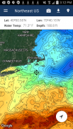
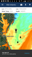
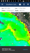
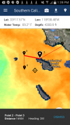
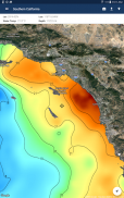
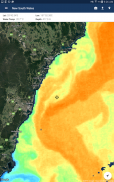
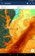
FishTrack provides saltwater anglers with everything they need to find fish. The FishTrack app offers free cloudfree sea surface temperature (SST) charts, global satellite imagery and marine weather forecasts – all in one layered tool.
With FishTrack you can:
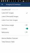
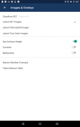
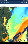
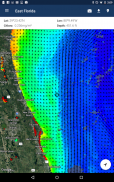
- View the latest SST, chlorophyll and true color satellite imagery
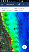
- Overlay bathymetry, ocean currents and sea surface height
- Save waypoints to mark fishing spots and catches
- Create routes to plan a trip and view distances and headings
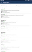
- View marine weather forecasts and tides/solunar tables
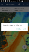
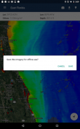
- Save fishing chart imagery for offline use
- View your current location both online and offline
Don't fish blind! FishTrack helps you plan a productive trip offshore. Burn less fuel and find fish faster.
We want to hear from you! Submit your questions or comments through our app to let us know what you think. If you'd like to speak directly with our customer service team, please e-mail us at: support@fishtrack.com.
FishTrack fornisce i pescatori di acqua salata con tutto ciò di cui hanno bisogno per trovare i pesci. L'applicazione offre la connessione FishTrack grafici cloudfree temperatura superficiale del mare (SST), immagini satellitari globale e le previsioni meteo marine - il tutto in un unico strumento a strati.
Con FishTrack è possibile:
- Mostra l'ultimo SST, clorofilla e la vera immagini satellitari a colori
- Overlay batimetria, correnti oceaniche e superficie del mare altezza
- Salva waypoint per contrassegnare luoghi di pesca e delle catture
- Creazione di percorsi per pianificare un viaggio e distanze e intestazioni
- Visualizza previsioni meteo marine e maree / tavole solunari
- Salva pesca grafico di immagini per l'utilizzo offline
- Mostra la posizione corrente sia online che offline
Non pesci ciechi! FishTrack ti aiuta a pianificare un viaggio in mare aperto produttivo. Bruciare meno combustibile e trovare pesce più veloce.
Vogliamo sentire da voi! Invia le tue domande o commenti tramite la nostra applicazione per farci sapere cosa ne pensate. Se vuoi parlare direttamente con il nostro team di assistenza clienti, si prega di inviare un'e-mail a: support@fishtrack.com.
FishTrack provides saltwater anglers with everything they need to find fish. The FishTrack app offers free cloudfree sea surface temperature (SST) charts, global satellite imagery and marine weather forecasts – all in one layered tool.
With FishTrack you can:
- View the latest SST, chlorophyll and true color satellite imagery
- Overlay bathymetry, ocean currents and sea surface height
- Save waypoints to mark fishing spots and catches
- Create routes to plan a trip and view distances and headings
- View marine weather forecasts and tides/solunar tables
- Save fishing chart imagery for offline use
- View your current location both online and offline
Don't fish blind! FishTrack helps you plan a productive trip offshore. Burn less fuel and find fish faster.
We want to hear from you! Submit your questions or comments through our app to let us know what you think. If you'd like to speak directly with our customer service team, please e-mail us at: support@fishtrack.com.
FishTrack - Fishing Charts - Versione 1.3.1
(19-01-2024)
FishTrack - Fishing Charts - Informazioni APK
Versione APK: 1.3.1Pacchetto: com.fishtrack.androidApp nella stessa categoria
Potrebbe piacerti anche...


